By Keli Kringel & Barb Kowalik, Board of Directors
(2012 Directors Report, Part 1 of 3)
Active Well Drilling Status
Klikus 2-19 Well ~2 miles west of La Veta
- SWEPI filed application with COGCC May 2, 2011
- 14,000 ft. deep exploratory well: deep gas.
- Includes giant frack flowback pit in shallow water table.
- LGD was not notified and public input period waived without public knowledge.
- COGCC permit was approved June 9, 2011 with minimal COAs.
- County public hearing held June 28, 2011. Despite huge public outcry, permitted the next day.
- No county Oil and Gas regulations in place at the time. CUP conditions were minimal.
- One of the voting commissioners (Roger Cain) had a lease with SWEPI at the time (and still has).
- COGCC Permitting process the subject of the CHC lawsuit vs. COGCC/Shell (still underway). County commissioners joined lawsuit on side of Shell/COGCC.
- This permit has not been drilled yet. Expires June 2013 and 2014.
 |
Klikus well approximately 2 miles west of La Veta near Middle Creek
|
Next four wells: NW of Gardner to Major’s Ranch
SWEPI filed 4 (8) more applications with COGCC on May 18, 2012
Each location has 2 wellbores:
vertical pilot hole ~10,000 feet deep
horizontal “toe up” hole out~1 mile and ~5,000 feet deep
- Target formation Niobrara, going for oil
- Public input was exhaustive, despite being un-notified by and denied simple10-day extension by LGD.
- COGCC permits were approved July 17, 2012 with COAs “better”
- Require no pits for fracking
- Require VOC reducers to reduce air emissions
- Meanwhile, the county had quickly adopted existing La Plata adapted CBM regulations as Oil and Gas regulations in Nov 2011
- Under new regs no public hearing was required (‘minor facilities’).
- The Huerfano County BOCC permitted all 4 on July 18 with no public input. CUP conditions were very slightly “better”.
- One of the voting commissioners had a lease with SWEPI at the time (and still has).
 |
Well span from Hwy 69 north of Gardner to majors ranch. Roughly follows the La Veta syncline. |
Jenny Well
 |
| Natural Resource Group, "Jenny Well" |
Natural
Resource Group’s “Jenny Well” was also filed on April 25 and approved
by COGCC on Oct 17, 2012. It also had public input given by CHC and had Conditions Of Approval's added by the COGCC.
COGCC Permits
COGCC Permits
All permits’ documents are on the COGCC website (click on PERMITS)
http://cogcc.state.co.us

County Oil and Gas Regulations

NOTE! Huerfano County oil and gas regulations are under revision again now. To review the new proposed regs go to the Huerfano County Land Use page at: http://www.huerfano.us/
Drilling Status of Permitted Wells
The first Well is the Freeman 3-24 in Major’s Ranch. Drilling is underway right now (started Nov 5 at 9pm).
 |
| Freeman well 3-24 in Major's Ranch |
 |
| Freeman 3-24 in Major's Ranch |
Freeman 3-24 Location
 |
| Lat:37.684831, Long: -105.067631. Cty Rd. 530 a few miles west of Yellowstone Rd. |
Community Work at the Site
For people living in the vicinity:
1. Requesting they complete a baseline health survey
2. Equipping them with an odor and symptom log
3. Give them the procedure to file complaints with the COGCC and EPA
2. Equipping them with an odor and symptom log
3. Give them the procedure to file complaints with the COGCC and EPA
If you live near the well or know someone who does, please email healthyhuerfano@gmail.com
Freeman Change of Direction
After the COGCC permit was granted, SWEPI changed the direction of the horizontal leg from North to Southeast. It is now headed into dikes. Reason given: to maximize perpendicular encounter of natural fractures.

CHC Complaint Letter to COGCC
CHC filed a letter of complaint about the issue to the COGCC. It is not illegal to change the plan after the permit is approved. But it does suggest due diligence on the substantial change was voided or never mattered/happened.

Baseline Water Tests
CHC is recommending baseline water tests be obtained around the dikes.

Shell Filings
Shell’s Freeman Plan per the Forum
All Shell forum materials are publicly posted at www.hughes-collaboration.com

Shell’s Mandatory Disclaimer of Forum Presentations
“There are a number of factors that could affect the future operations of Royal Dutch Shell and could cause those results to differ materially from those expressed in the forward looking statements included in this presentation…”

Freeman Project Schedule from Shell

To Frack or Not to Frack? (notes from Shell Forum)
- Question: What are the chances of fracking this wellbore?
-
There are two possibilities:
-
This well produces economically without fracking, in that case Shell may proceed to drill on the other permits.
-
Answer: None. *
- The well does not produce as hoped. In that case they might drill a new wellbore off the same surface hole in a new direction and fracture that new wellbore.
UPDATE AS OF 12/11/2012
A site tour was given to members of the forum on 12/11/2012.
Shell is now actually half way through Completion phase. The Oct 25 plan indicated they would be at that point in late February.
Question: What are the chances for fracking this wellbore?
Answer: “We are keeping our options open.” *
CURRENT possibilities:
- This well produces economically without fracking, in that case you will see a permanent pump jack at the site.
- The well does not produce as hoped. In that case they might frack this well. But they would need a new permit. Or if not a permit, at least some kind of paperwork filed with the COGCC…
*If these two answers appear inconsistent, they are. Please see the Cautionary Note above.
Editorial Projection
(not from Shell materials)
The below map shows multiple fracked directionals from each pad, increases underground “footprint” by adding toe-ups while surface impact is minimized. Giant underground fish-hook shape. Shell has named the project “Huerfano Sasquatch”.

Leasing
Shell has stated it has 140,000 acres leased in Huerfano County. Leasing began in force in 2009. This is the largest Oil and Gas play in the state without representation (we have no COGCC Local Government Designee).
 |
Pink = SWEPI Huerfano County Leases as of June 2012. |
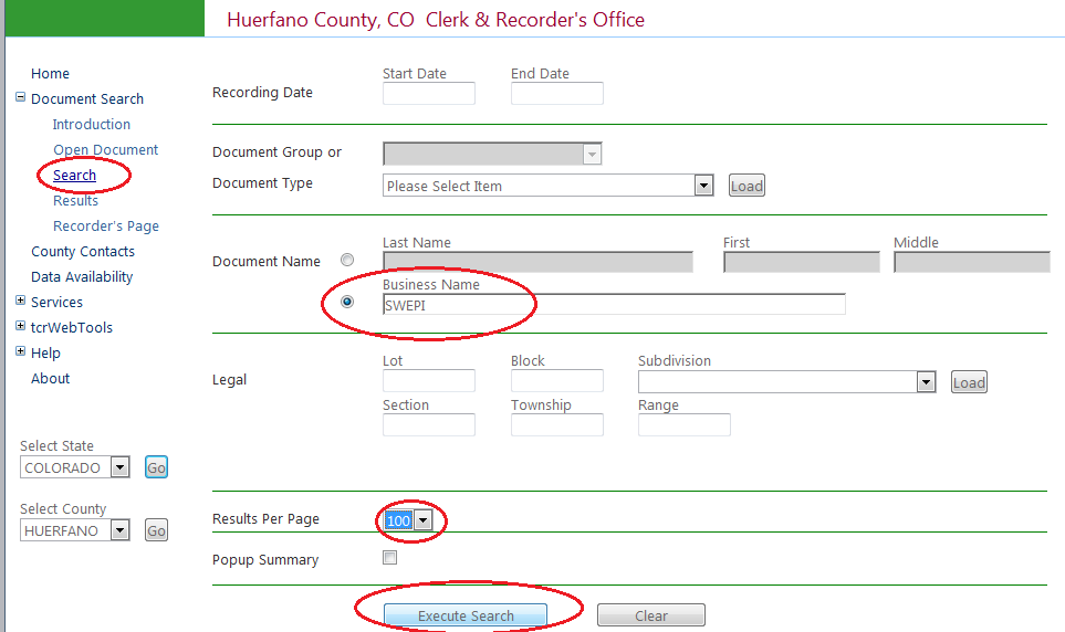
Recorded leases are on www.thecountyrecorder.com
Recent SWEPI Leases

And who is III Exploration II LP?

- Dec 2000: iii Exploration acquired 100% of Petroglyph stock.
- Sept 2001: iii Exploration transferred all oil and gas property and equipment to IIIX LP.
- Petroglyph, as a Class A Partner, exercises complete control over operations and governance of IIIX LP.
-
 |
| Leases bought in 2012 in the name of iii Exploration and Petroglyph. |
No comments:
Post a Comment